Navionics® Boating
- 2.9
- Rating
- 5.00M
- Installs
- Free
- Price
 Analysis by App-foxy
Choosing a navigation app for a boat is different from choosing a driving app. On the water, I care less about a flashy interface and more about chart detail, route planning, readable information, and how confidently I can check a passage before leaving the dock. That is the lens I used with Navionics® Boating, Garmin’s nautical navigation app for Android and iOS.
My overall impression is that it is aimed at people who want more than a simple moving map. It is built around detailed nautical charts and a broad set of boating tools, so it feels closer to a digital chart table than to an ordinary map application. The free download makes it easy to try, although the most useful chart access and advanced functions are connected to in-app purchases ranging from $49.99 to $149.99 per item.
That pricing immediately changes the decision. This is not automatically the best choice for someone who only takes an occasional short trip and wants a basic visual reference. For regular coastal cruising, fishing trips, route preparation, or anyone moving from paper charts to a phone or tablet, it deserves a serious look. I found its value depends heavily on how often you boat and how much planning detail you expect.
You May Also Like

 Blood Strike: 2.5 Anniversary
Blood Strike’s Loadouts Turn Every Drop Into a Tactical Gamble
A close look at Blood Strike’s custom loadouts: how fast access to signature weapons reshapes its battle royale rhythm, rewards preparation, and narrows the gap between fights.

 Pandora - Music & Podcasts
Pandora’s Music Is Easy to Start, but Harder to Recover
Pandora’s strength is its low-effort path from a seed to a station. Its weak spot is how much confidence it asks you to place in connection, setup, and quiet recovery.

 8 Ball Pool
 Is Built on Rivalries, Rematches, and Routine
A close look at the rivalries, rematches, shared routines, and unanswered safety questions that turn a quick pool match into a persistent mobile community.

 Samsung Music
’s Quiet Strength Is Playing What You Already Own
Its reach comes less from spectacle than from dependable access to a personal library. That simplicity is both the app’s strongest retention engine and its ceiling.

 AccuWeather: Weather Radar
AccuWeather Review: A Quick, Clear Forecast for Everyday Decisions
For everyday plans, the best forecast is the one you can understand quickly. AccuWeather makes rain timing, radar, and local conditions easy to act on, with a few trade-offs.

 Hill Climb Racing
Why Hill Climb Racing Still Turns Crashes Into One More Run
A tiny car, a bumpy hill and one more upgrade: Hill Climb Racing keeps resurfacing because its simple chaos makes every near-miss feel personal.
More From Our News Desk



What I would check before choosing a boating navigation app
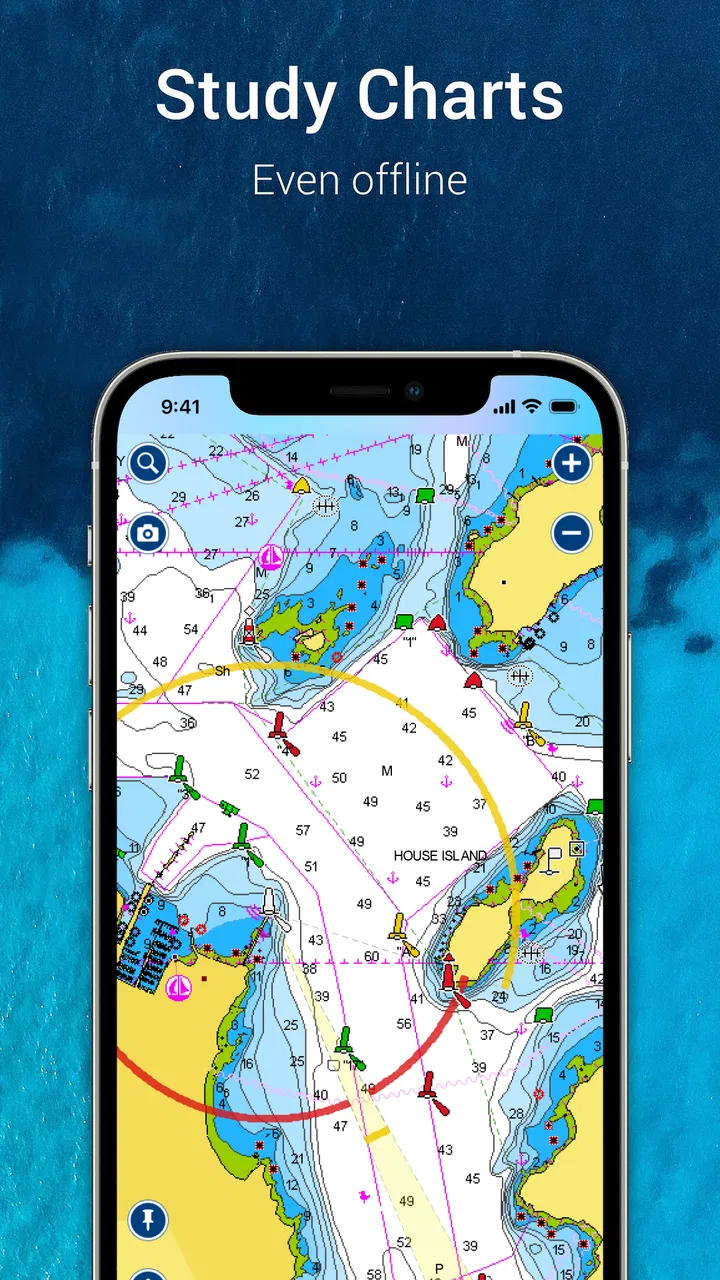
My first decision criterion is chart usefulness, not the number of buttons on the screen. A nautical chart needs to help me understand depth information, shoreline shape, hazards, markers, and the wider context of a route. I also want to zoom and pan without losing my place, because planning a trip often means switching between a close look at a harbor entrance and a broader view of the coast.
The second criterion is workflow. A good app should support the way boaters actually prepare: checking a destination, tracing a possible route, reviewing the surrounding water, and then using the device as a reference while underway. If each stage feels disconnected, an attractive chart still becomes frustrating. Navionics Boating makes the most sense when treated as one planning workspace rather than as a replacement for every instrument on the boat.
I also consider the device itself. A phone is convenient, but a tablet gives a much more comfortable view of a long route or a complicated harbor. Screen brightness, battery life, waterproof protection, and a stable mounting position matter just as much as the app. I would never treat a phone app as the only source of navigation information on an unfamiliar passage, especially when conditions can change quickly.
Another important question is whether I am paying for a chart subscription or toolset that I will actually use. The free starting point is useful for exploring the interface, but serious users should examine the purchase options inside the app before planning around premium access. The right choice depends on the waters I use, the kind of boat I operate, and whether I need occasional orientation or dependable preparation for repeated trips.
How the chart experience feels in practical use
The strongest part of the experience is the nautical focus. Instead of presenting the water as empty blue space beside a road map, the app is designed around marine chart information. That makes a difference when I am thinking about a harbor approach, a fishing area, or a route that crosses several coastal sections. The visual language feels appropriate for boating rather than adapted from a car-navigation product.
I found it helpful to begin planning from the widest view and gradually move inward. At the broad level, I can judge whether a route makes sense geographically. At a closer level, I can inspect the approach and identify places where I need to slow down, verify information, or consult another source. This habit prevents a common mistake: drawing a line that looks efficient on a large map but becomes questionable when the shoreline and navigation details are visible.
A useful tip is to prepare the route while I still have time and a good connection, rather than waiting until I am already leaving the marina. I would also keep a written note of the destination, intended route, and any critical bearings. The app is convenient, but a navigation plan should not depend on one battery-powered screen behaving perfectly for an entire outing.
The app is free to install and carries an Everyone content rating, which makes it accessible to a wide range of users. Garmin is the developer, and the product has been available since January 2, 2014. That long presence helps explain why it feels like an established boating tool rather than a recently assembled map experiment.
Where it is especially useful for regular boaters
I see the greatest benefit for someone who returns to the same coastal region but does not want to rely on memory. A familiar harbor can still look different in rain, low light, or a busy season. Having a chart-based planning tool lets me review the approach before departure, think through alternatives, and avoid treating familiarity as a substitute for preparation.
It is also useful for a realistic everyday scenario such as a weekend trip to a nearby anchorage. Before leaving, I can inspect the route on a larger screen, compare the direct path with a more sheltered option, and check the destination area rather than simply heading toward a point on the map. Once underway, the phone can provide a convenient reference, while the boat’s other equipment and normal lookout duties remain part of the process.
For fishing, the value is less about following a single line and more about understanding the surrounding water. A chart can help me organize several possible areas and plan how to move between them. That is a better use of the app than expecting it to make every decision for me. Weather, local knowledge, tide information, and conditions still need separate attention.
I also like the potential for route review after a trip. Even when I do not need a detailed record, looking back at where I went can reveal inefficient detours or places where I felt uncertain. That turns the app into a planning aid for future outings, not merely a screen I open when I am already confused.
Small workflow choices that make a real difference
One non-obvious trade-off is the difference between planning for distance and planning for confidence. The shortest line is not always the route I would choose. A slightly longer path may give me more room to assess an approach, avoid a cramped section, or keep the route easier to follow. I use the chart to compare these choices, not to reward myself for drawing the fewest miles.
A second practical insight is to use separate planning sessions for the overview and the details. If I zoom in too early, I can lose sight of the wider trip and create a route that is locally precise but globally awkward. If I stay zoomed out, I may miss the information that matters near shore. Switching deliberately between those views is more reliable than trying to plan everything at one scale.
A third is to treat the app as a conversation starter with local knowledge. If a route looks straightforward, I still want to ask a local skipper, marina staff member, or experienced crew member whether there are seasonal restrictions, tricky approaches, or conditions that are not obvious from a screen. The app can improve the questions I ask, but it cannot replace people who know the water firsthand.
Another useful habit is to keep the route simple enough to understand under pressure. Adding many points can make a plan appear thorough, yet it may become harder to read while the boat is moving. I prefer a clear route with meaningful checkpoints and then use the chart to inspect the surrounding area. That balance makes the app more useful when attention is divided between navigation, crew, weather, and traffic.
Where Navionics Boating wins, and where another approach may fit better
The clearest advantage is specialization. Compared with a general mapping app, this product is built for nautical chart work. A road-focused alternative may be excellent at finding a restaurant or street address, but it is not designed to answer the same boating questions. If my main need is understanding water routes and planning marine travel, a dedicated chart app is the more sensible category.
It also sits in a useful middle ground between paper charts and dedicated marine electronics. Paper remains valuable because it does not depend on battery power or a touchscreen, while onboard electronics can be better integrated into a vessel. Navionics Boating is appealing when I want portability, a familiar phone or tablet, and a planning tool I can use away from the helm.
That does not mean it replaces a chartplotter in every situation. A dedicated marine display may be easier to see in bright conditions, more suitable for permanent installation, and better connected to a boat’s instruments. If I spend long hours offshore or need a primary navigation system for demanding passages, I would view this app as a companion rather than the whole setup.
Paper charts may be the better choice for a boater who prefers a broad physical overview, wants a dependable backup, or dislikes managing screens and charging. They also make it easy for several people to examine the same area at once. The trade-off is that paper planning takes more manual work and does not offer the immediate convenience of a digital interface.
A basic free map may fit someone who only needs to identify a coastline or find a marina. In that case, paying for a specialized chart product could be unnecessary. I would skip Navionics Boating if I rarely go on the water, never plan routes, or only want a simple destination pointer. Its strengths become easier to justify when the app will be part of a repeated boating routine.
The average rating is 2.7 from roughly 47 thousand ratings, with about 2.4 thousand written reviews. I would read that as a reason to test the app carefully on my own device and in my own boating area, not as a final verdict. Navigation apps can receive very different reactions depending on chart coverage, hardware, purchase expectations, and the user’s experience level.
The cost of changing from a simpler option
Switching from a general map or paper-only routine has a learning cost. I need to become comfortable with nautical chart symbols, route editing, zoom levels, and the difference between looking at a chart and making a safe navigation decision. That learning period is manageable, but I would not begin with a complicated trip. A short, familiar outing is a better first test.
There is also a financial cost. The app itself is free, but in-app purchases are listed from $49.99 to $149.99 per item. Before paying, I would confirm exactly which chart coverage and functions are included for the waters I use. The important question is not whether the highest-priced option sounds comprehensive; it is whether the purchase matches my actual region and boating habits.
One way to reduce regret is to install the app before the next trip and spend time exploring the interface without making an urgent purchase. I would search around my usual harbor, inspect possible destinations, and see whether the chart presentation feels readable on my phone or tablet. If that first session already feels awkward, a larger display, a different navigation method, or a paper chart may suit me better.
I would also budget for the supporting equipment and habits that make any mobile navigation app practical. A waterproof case, a secure mount, a charging plan, and a backup reference can matter more than a small interface preference. The app cannot solve a dead battery or a screen that is impossible to read in sunlight.
For a person moving from a dedicated chartplotter, the change may be less about learning charts and more about accepting a different operating environment. A phone or tablet is flexible and portable, but it can be easier to bump, misplace, or deprive of power. I would use the mobile app for planning and backup first, then decide whether it earns a larger role onboard.
Who should use it and who should pass
I would recommend it to coastal boaters, sailors, anglers, and trip planners who want detailed marine chart information in a portable format. It is particularly attractive to someone who regularly explores new destinations but does not want to buy a separate navigation device for every planning task. The combination of a free download and paid expansion gives curious users a low-risk way to inspect the experience before committing.
I would be more cautious with complete beginners who assume that a chart app automatically makes a route safe. The app can support preparation, but seamanship still requires checking weather, understanding the boat, watching for traffic, respecting local rules, and maintaining a proper lookout. A beginner should learn those fundamentals alongside the app, not outsource them to it.
I would also pass if my main requirement is a full integrated helm system. In that situation, a dedicated marine electronics setup may offer a better primary display and a more suitable operating environment. Navionics Boating can still be useful for planning at home, but it would not be my only reason to abandon equipment designed for permanent onboard use.
On the other hand, I would not dismiss it simply because I own paper charts. The two approaches work well together. I can use the app to prepare a route and examine alternatives, then keep paper available for a wider overview and backup. That combination gives me digital convenience without pretending that one tool should handle every failure scenario.
My recommendation after weighing the trade-offs
My recommendation is positive, with a clear condition: choose Navionics Boating if detailed nautical planning is a regular part of your boating life. It is more focused than a general map app, more portable than a dedicated chartplotter, and easier to explore than a product that requires buying hardware first. The specialized chart experience is the reason to use it.
I would start with the free installation, test the chart view around my normal waters, and only then consider an in-app purchase. I would plan a familiar short outing, compare the app’s route with a paper chart or onboard equipment, and pay attention to how easily I can read it while seated in the actual boat. That test tells me more than a quick glance at screenshots.
The purchase range means casual users should think carefully before spending. If I only need a coastline outline once or twice a year, I would probably stay with a simpler alternative. If I routinely prepare passages, visit unfamiliar harbors, or want a portable chart companion, the cost becomes easier to defend because the app can support several stages of the trip.
With more than five million installs, it is clearly used by a substantial boating audience, but popularity does not remove the need for personal testing. Chart readability, device comfort, and local usefulness matter more to me than the install count. I would judge it by how confidently it helps me prepare, not by how impressive the feature list looks.
In the end, I see Navionics® Boating as a serious planning companion rather than a magic autopilot or a universal replacement for marine equipment. Its best qualities appear when I use it deliberately: study the route early, zoom between broad context and local detail, keep the plan understandable, and confirm important decisions with other sources. For that kind of user, it is worth trying. For someone seeking only a basic map or a complete helm replacement, another option will likely fit better.
FAQs for Navionics® Boating
01What features does Navionics® Boating offer for navigation?
Navionics® Boating provides a comprehensive suite of features designed for marine navigation. These include detailed nautical charts, sonar charts, and community edits. The app offers real-time GPS tracking, route planning, and weather updates, which are essential for safe and efficient boating. Users can also enjoy features like dock-to-dock autorouting and advanced map options.
02Is Navionics® Boating available offline?
Yes, Navionics® Boating allows users to download charts for offline use. This feature is particularly useful when navigating areas with limited or no internet connectivity. Users can save specific regions to their devices, ensuring they have access to crucial information even when offline, making it a reliable tool for all boating adventures.
03How does Navionics® Boating’s subscription model work?
Navionics® Boating operates on a subscription model, offering annual plans that unlock premium features. Subscriptions provide access to daily chart updates, advanced features like autorouting and weather forecasts, and the ability to download maps for offline use. It's important to review the subscription terms and check for any trial periods before committing.
04Can I use Navionics® Boating on multiple devices?
Yes, Navionics® Boating supports use across multiple devices. Users can sync their account, allowing them to access charts and saved routes on both Android and iOS devices. This flexibility is ideal for users who switch between devices, ensuring seamless navigation and data consistency across platforms.
05What kind of customer support does Navionics® Boating provide?
Navionics® Boating offers robust customer support, including a comprehensive FAQ section, user guides, and community forums. For more personalized assistance, users can contact support via email or through the app. Additionally, the app provides regular updates and troubleshooting tips to enhance user experience and address any potential issues.
Pros
- Comprehensive nautical charts available.
- Real-time weather updates included.
- User-friendly interface for easy navigation.
- Offline access to downloaded maps.
- Community-driven points of interest.
Cons
- Requires subscription for full features.
- Large app size may affect storage.
- Occasional GPS signal issues reported.
- Battery drain during extended use.
- Limited features in free version.

Navionics® Boating
Gallery